The Untold History of the GWEN Towers Military Psyop: Cell Towers. Cellphones. Google Maps. Nukes. Poisons Dumped From Our Skies. Underground Bases & Tunnels.
![]()
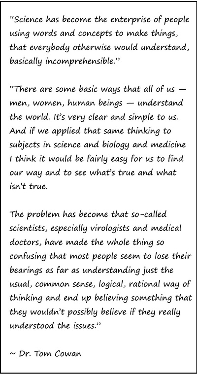
“To tie it all together, we first must go back in time to 1941, when The Five Eyes alliance was formed. The Five Eyes consisted of the United States, the United Kingdom, Canada, Australia, and New Zealand, agreeing to joint cooperation in intelligence, which means surveillance, which means spying.”
[…]
~ Agent131711, What if They’re NOT 5G Towers? Untold History of GWEN Towers: a Deep Dive into an 80-Year PSYOP
![]()
Truth Comes to Light editor’s note:
Below you will find key excerpts from Agent131711’s substack article “What if They’re NOT 5G Towers? Untold History of GWEN Towers: a Deep Dive into an 80-Year PSYOP“. I recommend reading the entire article as it includes much greater detail, many images, videos and reference links. Those familiar with Agent131711’s work will recognize his intelligent research and unique dot-connecting skills, presented in his (often-humorous) easy-to-read style. ~ Kathleen
What if They’re NOT 5G Towers? Untold History of GWEN Towers: a Deep Dive into an 80-Year PSYOP
by Agent131711
June 23, 2024
[…]
In the early 1980s, nukes were such a threat that television stations, like Channel 4, did its part to warn people by broadcasting shows like QED Nuclear War; A Guide To Armageddon which basically told the public, when the nuke hits, you and your family are going to burn to death. Then there was CBS news, who aired A Day Called X which explained what could happen to Portland, Oregon when it is attacked. Meanwhile, Bombs Will Make the Rainbow Break, had children explain to adult viewers how terrified they were of being nuked. Reliability and Risk: Computers and Nuclear War outlined how a simple computer malfunction could escalate into a national crisis, and let’s not forget about Protect and Survive Nuclear Explosions, produced by the UK government to explain all of the aforementioned. Time Life published a show called Nuclear Strategy for Beginners, informing the public that there were currently over 50,000 nuclear weapons in the world, and that is just to name a few. Based on the media’s involvement, clearly, citizens needed to recognize that nuclear weapon attacks were a grave concern for them. Although it was a time of peace, because of the fear of nukes, it was imperative that the US and its allies take proactive measures. Enter: The GWEN Towers.
GWEN stands for Ground Wave Emergency Network. The towers were a network of radio transmitters and receivers installed in the United States in the 1980s as a backup communication system in the event of a nuclear attack. These towers were designed to transmit low-frequency radio signals which would allow for communications to continue in the event of a nuclear explosion disrupting traditional radio systems (keep playing along here). So, the nuke hits us and decimates traditional communication methods, but it’s totally fine because the GWEN towers utilize a network of underground cables that work with 240 radio transceivers distributed across the continental USA (which also work on the same low frequency) therefore military and government co . Praise Jesus! – That’s the official story, just roll with it for a moment.
The Bizarre History of the GWEN Towers
In his 1985 inaugural address, President Ronald Reagan said, “A nuclear war cannot be won and must never be fought.”… but then, that exact same year, literally the same f*cking year, the Air Force began constructing the GWEN towers, which the Reagan administration said were a key component of its strategy for “supporting controlled nuclear counter-attacks over a protracted period.”. These towers were verbally sold to the public as protection against the Soviets who were planning to nuke us, hence the urgent need to get them installed pronto, even though a nuclear war must never be fought…
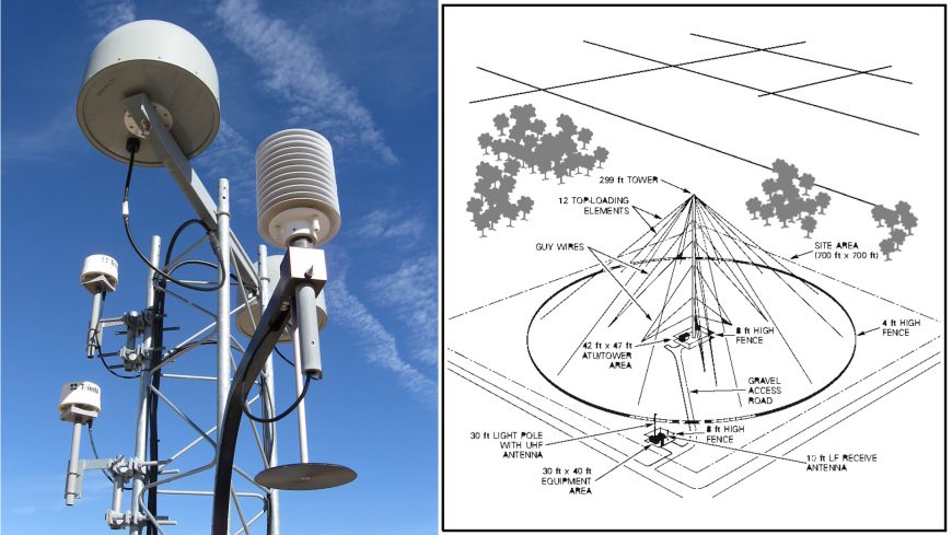
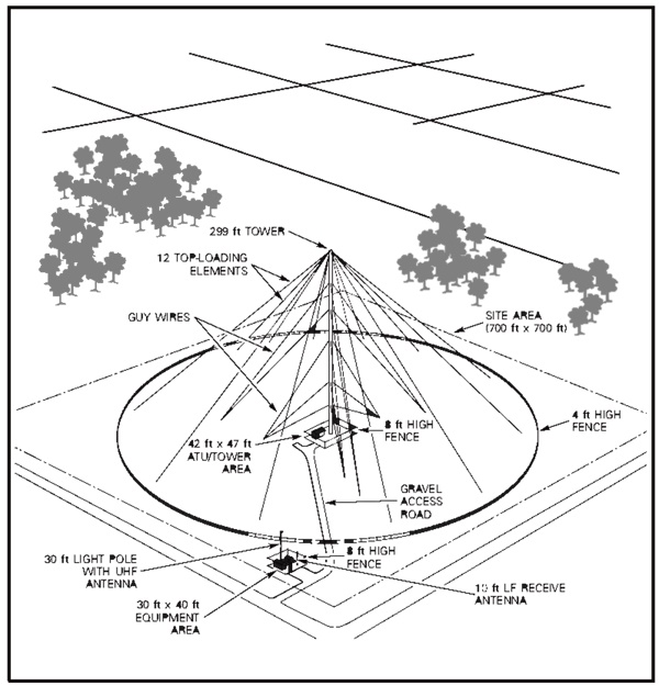
As part of the Pentagon’s Ground Wave Emergency Network, each tower was 299 feet tall (91 meters) and featured guy wires with a steel trusswork structure. Yes, 299 feet, not 300, and each tower cost $1.4 million. The entire system was planned to cost a billion dollars (thank God we cut it off at 299 feet. Imagine the cost with the added foot). Here’s a little diagram for you, so you can see what your hard-earned tax money bought you:
The truth was, citizens across the nation were pointing out that it doesn’t make sense, “Wouldn’t the Soviets aim for the GWEN towers? Wouldn’t this make my neighborhood a massive target if one is in it?”, they asked.
Because it didn’t make a damn bit of sense and government wasn’t providing adequate answers, citizens began becoming highly suspicious of what was actually going on here. To get the public to STFU, the Department of Defense and other military agencies sent representatives to hold public hearings in some of the areas of the installs. The purpose of these hearings was to assure the citizens that the towers were just for Soviet nukes, communications and counter attack stuffs (for their safety, of course) and everything else was conspiracy theory (technically, the word at the time was misinformation)…
[…]
The peoples outrage was ignored, hazard studies were hastily performed and marginal at best, and the towers were rush-installed across the USA because the safety of the people must come before the safety of the people because nuclear war was at our doorstep! Makes sense to me! Oh, and they were also put up all over Canada…
[…]
What the general populous didn’t know was that behind the scenes, in 1996, Presidential Decision Directive NSTC-6 was penned. This directive designated the Department of Transportation (DOT) as the “lead agency for all Federal civil GPS matters”. In addition, the President directed the DOT to “develop and implement U.S. Government augmentations to the basic GPS for transportation applications.”. In normal people speak, he was like, “I command you to expand the GPS system!” (then he ate a handful of grapes, brought to him by a squire, on a plate made of solid gold).
Less than a year later, in January of 1997, the DOT formed an interagency DGPS Executive Steering Group to investigate the development of a nationwide GPS system. The four-letter group was like, “You know, it would be really nice of us if we saved the taxpayers money for once. What could we do to save them a few bucks? AH HA! What if we could save them money by building this newfangled GPS system upon existing infrastructure?!”. (You totally see where this is going, right?…)
Then, someone within that 1997 DGPS group was like, “Yo! We got those GWEN Towers that the military just blew hundreds-of-millions-or-maybe-a-billion of the peoples money to build and they don’t work. It would be a shame to waste them, so you just wanna use those?”. The group was like, “And those all nukes suddenly aren’t a problem, so we totally should!”.
So, in 1998, with the fear of nukes forgotten, the US Department of Transportation in conjunction with the US Coast Guard and Department of Homeland Security proposed repurposing 29 of the existing GWEN towers. Those 299-foot GWENs were now officially suggested to be used to construct a Nationwide Global Positioning System. The proposal document is now scrubbed from the US Coast Guard / DHS site…
[…]
Then they started converting the gosh-darn-don’t-work GWENs into GPS’s…
[…]
So, we deployed the towers for the second (known) time in 1996, then randomly decided they didn’t work. Instead of fixing them, less than a year later a make-a-massive-GPS-system team was assembled and less than a year after that (which was under 24 months after the second known deployment) we already had a plan to use the towers for a totally different purpose than the nukes which they were rush-installed for… and this is where sh*t starts to get crazy…
The Mindf*ck, Part 1:
In 1998, (yes Sweetheart, it was indeed the exact same year the military and DOT officially proposed reusing those 299-foot-failure-towers that the DOD fought so hard to get installed against the people’s wishes cuz nukes), two men, Larry Page and Sergey Brin did something history-changing… they launched Google.
During the same timeframe, the CIA had launched its own business called In-Q-Tel. In-Q-Tel was a Silicon Valley venture capital fund whose mission was to invest in tax dollars in start-up companies because why the hell not?
In 1999 and 2000, Saddam Hussein was still whipping up Weapons of Mass Destruction even though he had been told to stop (don’t worry babe, he would later throw them all away and destroy all evidence of them existing, but that is later in the timeline. At this point, we are very afraid of what this mad man will do with his WMDs). It was a cryin’ shame those towers didn’t work to protect us but at least the good government found a new use for ‘em.
This brings us to 2001, a year when something nobody would have ever expected to happen, happened. It was not a Soviet nuke that attacked the USA. It wasn’t a Saddam WMD, no ma’am, it sure wasn’t. It was actually a dude, living in a hole in a desert far, far away, who sent his men, the terrorists, to the USA to hijack airplanes and fly them into steel towers so the US Military could retaliate by obliviating his country.
And, I’m sure it’s completely nonrelated, but did you know that shortly after the terrorists airplanes cut through those steel skyscrapers like a hot knife in butter, 3G became operational in the USA? Well technically, it would later be realized that we have no idea when exactly 3G became operational, but we can infer it was 2002 because this is when the people learned of it…
[…]
March 20th, 2003: The US invades Iraq. For you youngsters that don’t remember why exactly we invaded this country, there was a laundry list of reasons, which meant everyone could choose the reason, or reasons, they liked best…
[…]
97 days post-invasion: Call it irony, call it fate, perhaps it was destiny or just good luck, it just-so-happened that In-Q-Tel (the CIA), while scouting for investments, found a company desperately in need of the people’s tax money. This company was called Keyhole. The story is that Keyhole was somehow developing cutting-edge mapping technology… just like their investors, the CIA, did back in the 1960s. Do you know what the CIAs 1960s cutting edge mapping and spying program was called? Go ahead and guess…
ANSWER: KEYHOLE! IT WAS F*CKING CALLED KEYHOLE! You can’t make this sh*t up…
[…]
The following year, while the War in Iraq was raging and the military was trying so damn hard to locate Osama Bin Laden’s hole and Saddam’s Weapons of Mass Destruction, despite Keyhole being funded by tax dollars and used by the CIA, Pentagon and CNN, someone popped up out of the blue and bought it. That someone was Google.
[…]
Then, within months, Google Maps was released…
[…]
And shortly after, Google Earth Viewer was released using the identical technology used to map and spy on Iraq combined with the (GWEN Tower) GPS system. Yes, the technology was now sold to the American people as being helpful tools, not a tax-funded military spy system. Isn’t it to cool that we can zoom in on your house?…
[…]
Google launched Google Federal, which is exactly what it sounds like. Google Federal hired managers and staff from the Army, Air Force, CIA, Raytheon and Lockheed Martin. They landed a bunch of intelligence-related contracts, including with the NSA.
Researchers on Team Truth began looking into these GWEN Towers, now being called 3G Towers, and what they discovered was shocking…
[Here Agent131711 shares a clip from this video, uploaded to YouTube in 2013]
Mindf*ck Part 2: The Satellite Photos
And if that wasn’t odd enough, as we looked at “Satellite photos”, we began realizing there were no airplanes in any photo…
[…]
How is this possible? If the satellite is in space, surely airplanes would be between the cartoon satellite and Earth, right?…
[…]
In fact, there are a sh*t ton of planes in the sky…
[…]
You’d think, if the satellite is at this height, or higher, some would get in the photo, right?…
…yet none are in any satellite photo…
[…]
Not even a flock of seagulls…
[…]
After discovering satellites are actually airplanes and balloons, I assumed they must be flying under the normal level of planes, because how else would planes not get in the photos? Yet that can’t be true because when have you ever been on a plane and flown over a giant balloon? Never…
[…]
But the icing on the cake of strangeness was there were no airplanes in airports either!…
[…]
No planes in between the satellite and the airport and no planes in the airport itself…
[…]
And every satellite photo I could find was like this!
This photo was taken by the International Space Station and still no planes!…
[…]
It didn’t make any sense… until today, when it hit me…
THESE AREN’T PHOTOS, THEY ARE A.I. CGI! THAT IS WHY THERE ARE NO PLANES ANYWHERE! This is why birds do not get in the photos. This is why there’s never a hot air balloon tour blocking the satellite photo over the Grand Canyon. There’s no clouds, no rain, no little Cessna airplanes Cloud Seeding. This is why nothing gets between the satellite and the ground! These images are not coming from something orbiting in outer space while the earth spins at 1,000 mph. These images are not even from balloons or planes. These are nothing more than 3D graphics coming from cutting-edge GPS mapping! My mind is officially blown.
Need more proof? Yes you do, because you are on Team Truth and you refuse to settle for someone saying something so outlandish without evidence, so bear with me here: I am not a technology person, but you don’t need to be a techie to understand what I am about to show you. I located this video, uploaded in 2016, which appears to show the back-end inner-workings of Apple’s map system, which is the same as Googles (although I would guess Googles is far more advanced). Whoever the person is who uploaded this video also uploaded another of the same nature. It appears they are part of the development team for the map system, because in their other video they appear to be programming locations on the back-end of Apple maps. But what they are doing doesn’t matter, just watch and you will see, it is all CGI with photos taken from the ground added in: (2:34 video)
[Here he shares a video clip found at Internet Archives]
[…]
Mindf*ck Part 3: Piecing the Puzzle Together = Major Revelations
To tie it all together, we first must go back in time to 1941, when The Five Eyes alliance was formed. The Five Eyes consisted of the United States, the United Kingdom, Canada, Australia, and New Zealand, agreeing to joint cooperation in intelligence, which means surveillance, which means spying.
Only a few years after the formation of the worldwide spying collaboration, The Federation of American Scientists and Philip Ragan Associates began publishing Atomic Bomb content which warned of the threat of nuclear war coming to American and our allies, and Oh Thank God the Five Spies Eyes was just established because now they could save the people through mass surveillance! (This is the first video they released in the 1940s. It’s 9 minutes long and worth your time to watch the extreme propaganda.)
[Here he shares the One World or None video, which can be found at Archive.org.]
Only four years later, on October 24, 1945, the United Nations was established.
Only a matter of years after that, the CIA was Keyholing and Operation LAC was taking place.
Operation LAC
Operation Large Area Coverage (LAC) took place in the 1950s and involved the United States military, Canada and Britain dousing select cities within their countries with Zinc Cadmium Sulfide, a toxic glowing compound. The alleged purpose, as we have been told, was to simulate what would happen during a chemical or biological attack, specifically, they wanted to know how far the chemicals would disperse. So, to simulate an attack, the nations sprayed toxic chemicals all over their countries. That actually happened…
[…]
Operation LAC never made sense to me, but neither does the majority of the military experiments so I didn’t put much thought into it… until today.
Let’s switch gears for a moment.
How Mapping Works
Quote, “Radar, sonar and lidar can determine an object’s distance, or range. For that measurement, time plays an important role. Lidar, radar and sonar systems all include timing devices. Their clocks record the length of time needed for a wave to travel to an object and back. The farther the distance, the longer it takes for an echo to return.
Radar, sonar and lidar also can reveal information about an object’s shape, size, material and direction…. lidar helps read the lay of the land or features on Earth’s surface. Lidar’s laser pulses can penetrate forest cover to record the shape of the ground below. That makes this technology especially valuable for mapping.”
[…]
The Revelation
I’m pretty damn sure Operation LACs Zinc Cadmium Sulfide was not used to simulate a biological attack and was instead used for mapping purposes for the military and CIA Keyhole spying program as part of The Five Eyes. The metals in Zinc Cadmium Sulfate, dumped over major cities, allowed for the sonar / lidar signals to reflect evenly.
[…]
Occam’s Razor: My theory is, the reason they wanted the materials they dispersed to glow was to ensure the ground was fully covered for the mapping… which makes a helluva lot more sense than dousing your countries major cities in chemicals to see what a biological attack would look like when you have no idea which biological materials a hostile nation would have chosen to release let alone where the enemy would have chosen to release them or even what method they would use to disperse them. They selected main cities to be coated in chemicals because that was where they wanted to test out mapping. FFS, the name of the operation was Operation LARGE AREA COVERAGE.
Google / CIA / Pentagon / DHS / NSA / Dot Mapping & Bombshell Revelations
We know graphene oxide, along with Smart Dust, is coming down in rain water and snow….
[…]
Smart Dust Graphene is nanotechnology, “no bigger than a grain of sand”…
[…]
It can be deployed into the sky by aircraft. In fact, they are now researching having unmanned aerial vehicles deploy it…
[…]
What is released into the sky will eventually come down in the rain and snow. But why release it in the first place? It turns out that Smart Dust has a variety of uses including numerous military applications. The military uses include reconnaissance and surveillance…
[…]
But that’s not all. Smart Dust is also used by the military for …
…
… (pause for suspense)…
…
MAPPING!: IT IS USED FOR MAPPING!
[…]
Now watch how fast this timeline goes:
1940s through 1994: “Ze Noookz are coming!”
1995: Second known GWEN Deployment
1996: “It doesn’t work. Let’s use it for something else” and “How ‘bout a nationwide high-tech spy system GPS?”
1997: Converted 29 of the GWEN Towers into part of the nationwide GPS system
ALSO IN 1997: Smart Dust was funded by DARPA
2002: 3G network goes live to the public and most of the tower panel ownership information is hidden from the public.
2003: The CIA’s In-Q-Tel inked the deal with Keyhole for their mapping program
2004: Google quickly bought the tax-funded Keyhole
Also in 2004, the same year Google bought Keyhole, a document was published relating to the creation of “smart clouds” using Nanotechnology…
[…]
2005, Google Maps and Navigation were released, CGI programd developed using cutting-edge mapping.
2007, reports of clouds falling to the ground began appearing, but were quickly labeled tinfoil hat nonsense and “edited videos”:
[Here Agent131711 shares seven short YouTube videos 1 2 3 4 5 6 7.]
2008, Google fully integrated Street View into Google Earth (combined the cutting-edge mapping with real photos and videos taken from the ground)
[…]
In 2009, with strange clouds still unexplainably falling to the ground, Google Earth 5.0 was released which featured Google Ocean, followed by Google Great Lakes.
[…]
How’d they do it? I would have to assume the tax-funded GPS system on the GWEN Towers was used with DARPA-funded Smart Dust to map the country just like OPERATION LAC that took place during the same time the CIA was running Keyhole for spying and mapping. I expect that these towers may not be able to stretch across oceans, therefore, to map over large bodies of water, Smart Clouds were developed. …but it gets crazier…
Mindf*ck Part 4: The Final Piece Is Inserted Into the Puzzle
[…]
Because of the fear of nukes, the militaries of the world built Deep Underground Military Bases (D.U.M.Bs) and were heavily planning utilization of the tunnel system in the United States, including utility tunnels:
[…]
Was the military truly planning to save the people from a nuclear attack? Or just themselves? Or was everything just an illusion? Or is it deeper than that?
We know these evil doers we are dealing with play the long game. While you and I plan what we will have for dinner a day in advance or we might plan a vacation a year in advance or even set a 10-year-goal, these villains have plans spanning literal centuries.
Operation LAC and the CIAs Keyhole spying and mapping took began in 1950.
45 years later, the GWEN towers were deployed for the second known time
55 years later, Google released the ultimate spying and mapping technology upon the American populous
What is 100 years after 1950? Agenda 2050, which is slotted to be, essentially, the end of the world as we know it.
To understand these evil doers, you must understand that they believe in the Revelation of Method (RoM), also known as The Law of Karma, or, as I call it, “they have to show us”. They believe that if they tell us what they are going to do before they do it they are relieved of all bad karma, regardless of terrible their actions are. The specific method they use to show us varies. It can be symbolism, phrases repeated in the media, news headlines, the method is flexible, as long as the citizens are shown what will happen…
[…]
Folks, they have spent 80 years telling us a nuke is coming which will create a massive flash followed by a radiation nightmare.
[…]
They then built the GWEN Towers. The GWENS are the machines assembled by saboteurs
[…]
They converted the GWEN Towers into radiation weapons, also known as nukes but, before they can nuke us using their radiation towers, they needed to map us. They used the maps to determine where more towers needed to go to ensure full coverage of the United States
[…]
[…]
[…]
Meanwhile, We the People, should Duck and Cover..
Connect with & support the work of Agent131711 at substack
Cover images credits:
Tom.jennings — Photo of the differential GPS gear added to
the Essex, CA GWEN site; California, USA. (Trimble gear).
US government public domain — Diagram of a US military Ground
Wave Emergency Network automated radio relay station


Truth Comes to Light highlights writers and video creators who ask the difficult questions while sharing their unique insights and visions.
Everything posted on this site is done in the spirit of conversation. Please do your own research and trust yourself when reading and giving consideration to anything that appears here or anywhere else.


